
 MARINER'S
WEATHER
Maritimes
Maine
New Hampshire
Massachusetts
Rhode Island
Connecticut
 Marine
Forecasts
Buoys
Sea Temp
Conditions
Satellite/Radar
Web Cams
Hurricane
TIDE CHARTS
Downeast ME
Midcoast ME
Southern ME
Seacoast NH
No. Shore MA
Boston Harbor
So. Shore MA
Cape Cod
The Islands
Buzzards Bay
Rhode Island
Connecticut E
Connecticut W
CURRENTS
Cape Cod Canal

Current
Moon Phase

|
|

|
Maritimes
 Coastal & Marine
Forecasts
|
|
|
Click a Location for Current Forecast

|
|
|
Marine Conditions and Forecasts
|
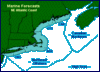
MARINE FORECASTS
Coastal Marine Forecasts from the Canadian Maritimes to Sandy Hook, NJ plus Offshore and High Seas Forecasts
|

|
INTERACTIVE BUOYS
Near real time marine observations from sea buoys and CMAN stations
|
|
SEA TEMPERATURE
Current sea surface temperature satellite images from the NOAA Office of Satellite Data Processing
|

|
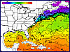
SEA CONDITIONS
Current NW Atlantic wave height, wind speed and pressure charts from NOAA's Ocean Modeling Branch and Penn State
|
|
|
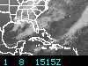
Satellite and Radar Images
|
Web Cams

|
Salty WEB CAMS
Links to Web Cams around New England with a salt water view - a real time window on the weather
|
|
Atlantic Hurricane Season
|
H u r r i c a n e 2 0 0 5
June 1 - November 30
Outlook, Discussion, Forecasts & Advisories, Summaries, Current Conditions for hurricane region locations, Marine Forecasts and a full set of satellite images.
|
-- Weather Tools --
TEMPERATURE (Fahrenheit, Celsius, Kelvin)
TIME CONVERSIONS (UTC, GMT, 24 hour)
WIND SCALES (Beaufort, Saffir-Simpson)
WIND CHILL (Old vs New, Frostbite chart)
WEATHER CALCULATORS
If you have questions or comments please visit our
Frequently Asked Questions page
or send e-mail to
webmaster@maineharbors.com

|
